NORTH CAROLINA DEPARTMENT OF TRANSPORTATION
Archaeological Predictive Model/GIS
Program Description
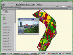
Screenshot of model application.
(Source: North Carolina Department of Transportation,
2003 Task 1 Report.)
Program Benefits
- Provides constraint mapping and summary tables quantifying a project’s potential to impact archaeological sites.
- Provides preliminary information on archaeological sensitivity without conducting archaeological field investigations.
- Streamlines assessment of potential archaeological impacts within proposed project alternatives.
- Provides a mechanism for defining the scope, cost, and scheduling of archaeological investigations within alternatives under consideration.
- Assists in avoiding high archaeological sensitivity areas.
North Carolina DOT (NCDOT) has a Geographic Information System (GIS) database that predicts and quantifies the potential for archaeological sites within proposed project areas. The GIS currently encompasses seven counties, but is anticipated to eventually cover the entire State. NCDOT also hopes to add historic architectural properties to the database. Information on the latter would provide immediate access to information on potential Section 4(f) properties. The archaeological predictive model/GIS currently is used during early project development, but a future goal is to have it become a transportation systems planning tool. NCDOT planners, however, do have access to the GIS either through the State Historic Preservation Office or through the DOT’s historic preservation staff.
Setting Up the Program
The value of having an archaeological predictive model was recognized by a NCDOT archaeologist who championed the modeling project. This individual prepared a scope of work for the project, which went through several internal reviews, including one by the State Transportation Board. The contract for developing the archaeological predictive model was awarded to a consortium of private sector consultants, beginning with a pilot program.
NCDOT’s partners in conducting the pilot program included the Federal Highway Administration (FHWA), the State Division of Cultural Resources (i.e., the State Historic Preservation Office (SHPO)), the Office of the State Archaeologist (OSA), which is within the Division of Cultural Resources, and the project consultants. Other entities with experience in managing archaeological sites, such as Fort Bragg, also were involved in the program. NCDOT entered into a Memorandum of Agreement (MOA) with the SHPO and OSA to establish a collaborative relationship between the agencies for this project.
The project was divided into two tasks. Task 1 involved digitizing all existing archaeological site records for the seven-county study area. These records were housed at the OSA. These data were used to populate an archaeological site data layer within NCDOT’s existing GIS database. NCDOT also collected additional data on environmental variables for use in developing the predictive model. The second task involved building the model, testing its statistical validity, and evaluating the model’s use as a planning tool. Task 2 was completed by 2006.
Funding for the modeling project came from State Planning and Research funds. Total project costs were approximately $900,000, which was used to pay the consultants and to purchase some equipment. Salaries for DOT personnel involved in the modeling project also came out of the same funding source.
Program Elements
- Historic Preservation in Early
Project Development
- Geographic Information Systems
- Historic Property Database
- Identifying and Mapping
of Archaeological Sensitivity
Challenges Encountered
NCDOT encountered technical problems in developing the model, and also had to educate some of its agency partners on the modeling process. There was no uniform learning curve among the DOT’s partners, so bringing them up to speed on the modeling project’s development process added time to developing and implementing the model.
Program Maintenance
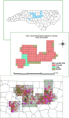
Model maps identifying state, target counties,
and site and survey data for target counties
(Source: North Carolina Department of Transportation, 2003 Task 1 Report.)
NCDOT now reviews 400-500 projects each year under a Programmatic Agreement among FHWA, the North Carolina SHPO and NCDOT. This has led to a broader emphasis on GIS mapping use that was in part spawned by the data created for the original predictive model.
The program is maintained using State Planning and Research Funds.
One of the current challenges affecting the modeling program is remote access to new historic property information, which is maintained by the SHPO. The SHPO has created an on-line product that currently only shows standing structures; however, plans are underway to add digitized archaeological site locations.
Critical Factors for a Successful Program
The two top factors that have contributed to the success of the program are:
- Sufficient funding for the project; and
- Highly skilled staff to do the work.
In retrospect, adding both GIS and geographic positioning system professionals to the archaeology staff at the start of the program would have helped with its development.
June 1, 2012

