Case Studies Highlight Benefits of Multimodal Roadway Design
and Green Infrastructure

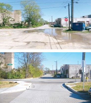
Johnson Street in Chattanooga before (top) and after (bottom) the redesign addressing flooding risks while providing a bicycle- and pedestrian-friendly green street (image courtesy of
FHWA).
The Federal Highway Administration (FHWA) recently published a set of case studies as part of its efforts to document and promote connected pedestrian and bicycle networks in communities throughout the United States. Networks are interconnected pedestrian and/or bicycle transportation facilities that allow people of all ages and abilities to safely and conveniently get where they want to go. The case studies are designed to provide information for agencies interested in improvements to their pedestrian and bicycle networks that incorporate green infrastructure and resiliency benefits. The information provided on stormwater and mobility benefits will help communities better understand the variety of goals and outcomes they can achieve through their projects.
FHWA works with its State and local partners and other stakeholders by providing technical assistance to successfully implement green infrastructure projects alongside pedestrian and bicycle improvements to manage stormwater runoff, improve water quality, and create healthier environments through strategies such as increasing pervious material and creating bioswales. At the same time, State and local agencies are working to promote resiliency and relieve burdens on overcapacity stormwater systems. As part of this effort to promote connected pedestrian and bicycle networks, FHWA identified, evaluated, and categorized these case studies into several project types including flood risk mitigation, public-private partnerships, multimodal network connectivity, and State and locally driven projects. The categories and a summary of the case studies are highlighted below and are described in more detail in the full report, available here.
User-friendly Design Minimizes Future Flood Damage
Flood mitigation involves the management and control of flood water movement, such as redirecting flood run-off through the use of floodwalls and flood gates, rather than trying to prevent floods altogether. These projects incorporated elements to address local flooding and minimize future flood damage:
Key Terms for Green Infrastructure and Pedestrian Features
Bioswales are vegetated, shallow depressions designed to capture, treat, and slowly infiltrate stormwater runoff.
Bulbouts, or curb extensions, are traffic calming measures that extend the sidewalk and reduce the crossing distance for pedestrians. They can also incorporate green infrastructure elements, such as landscaped rain gardens.
Flow-through planters are landscaping structures that capture and treat runoff before it filters into an underdrain system.
Permeable paving refers to various methods of paving that allows for stormwater infiltration, reducing surface runoff and filtering pollutants.
Rain gardens are slightly depressed, landscaped areas designed to collect and infiltrate stormwater. They are similar to bioswales, but are usually smaller.
- The city of Chattanooga, Tennessee and a developer agreed to a public-private partnership to transform Johnson Street into a bicycle- and pedestrian-friendly green street that addressed flooding risk and complied with the city’s mandate that new developments reduce or detain stormwater runoff during rain events. This shared street with permeable pavers is an application of design flexibility that meets the needs of all users, while doubling as stormwater management, capturing the first inch of runoff during storm events and eliminating regular flooding from heavy rains.
- The redesign of 21st Street in Paso Robles, California, stretches five blocks along a mixed commercial and residential street and included the replacement of all existing elements in the right-of-way, from the underground stormwater infrastructure to the travel lane striping and sidewalks. A day-lit channel and underlying infiltration trench that runs in the median replaced the underground storm pipes. 21st Street’s original design did not accommodate pedestrians and cyclists, and the city saw this stormwater makeover as an opportunity to not only green the street, but also complete the street for all users. The final treatment added ¾ of a mile of striped, on-road bicycle lanes, Americans with Disabilities Act (ADA)-compliant sidewalks, curb extensions at each intersection, two pedestrian-activated flashing yellow lights at the highest volume intersections, seating, 81 street trees, high-efficiency lighting, bicycle racks, and informational signage about the transformation.
- Prior to the completion of the project, the three-mile Hahn Arroyo in Albuquerque, New Mexico, resembled many concrete-lined stormwater channels throughout the Southwest. With the stormwater and active transportation project completed jointly by the Albuquerque Metropolitan Arroyo Flood Control Authority and the city of Albuquerque, the land now serves the dual purpose of managing stormwater and providing recreation space for local residents along the new Paseo del Nordeste Trail. An in-channel water quality structure and underground cisterns manage the Hahn Arroyo’s stormwater, removing pollutants and cleaning stormwater water before it enters the Rio Grande. Additionally, both a paved bike path and dirt pedestrian path were included in the design, and seating, lighting, bike parking, bike air pump stations, and public art are interspersed along the trails.
- Despite a relatively small population of 1,500 and a limited municipal budget, Edmonston, Maryland, was among the first Washington, D.C. suburbs to complete a green streets project. As part of the project, Edmonston narrowed travel lanes and added on-street designated bike lanes, while reducing the total amount of permeable surface. The project also included planting of native trees, installing wind-powered lighting, rebuilding all sidewalks and crosswalks with permeable pavers, and adding curb extensions with rain gardens.
Innovative Financing Spurs Economic Development and Enhances Connectivity
The Federal government encourages the use of innovative financing through an array of mechanisms and initiatives designed to provide flexibility in the ways projects are delivered. Public-private partnerships, one such mechanism, are cooperative arrangements between two or more public and private sector entities. These projects were implemented collaboratively with input and funding from several public and private partners:

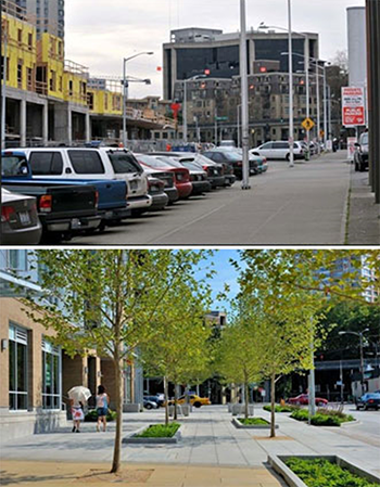
Taylor Avenue North in Seattle before (top) and after (bottom) the redesign project providing both space for bicyclists and pedestrians and stormwater management (image courtesy of FHWA).
- Located in northeastern Iowa, West Union, with a population of 2,500, implemented one of the most sustainable downtown revitalization projects in the country. Streets and sidewalks were rebuilt with permeable pavers and stonework. Four intersections received high-visibility crossing treatments using permeable pavers, and mid-block crosswalks were installed in the areas of highest pedestrian traffic. These sustainable improvements are expected to save West Union $104 million in operating costs over the next 50 years and the project spurred additional investment and growth downtown.
- The newly inaugurated “Connective Corridor” links downtown Syracuse, New York, and the Syracuse University campus with two miles of multimodal green streets along University Avenue and East Genesee Street, incorporating pedestrians, cyclists, transit, and automobiles. The project improved connectivity by adding raised and separated two-way bike lanes, widened sidewalks, streetlights, sidewalk furniture, and wayfinding signage.
- As the first mixed-use apartment building in the Denny Triangle neighborhood, the Taylor 28 project transformed an arterial roadway in downtown Seattle, Washington, into a multi-use corridor. This project was completed as part of a new development and paid for by the property owners, but required creative thinking and flexibility from both the city and the developer. The project includes sidewalks that are at least 38 feet wide, captures stormwater in rain gardens, features generous space for pedestrians and bicyclists, and includes landscaping and seating that create a sense of space unique to the street.
- Starting with a five-block pilot in 2007, the Indianapolis Cultural Trail transformed downtown Indianapolis from an autocentric grid of arterials to a space that is welcoming to all modes. The Cultural Trail is a unique example of a separated bike and pedestrian trail running through a downtown center. Stormwater management and resiliency were also central to the trail design, which weaves 25,000 square feet of bioswales throughout downtown, adding eight acres of green space and 500 trees.
Multimodal Networks Improve Access to Neighborhoods, Services, and Amenities
Multimodal networks help to facilitate a range of bicycling and walking trips, including access to work from residential areas, travel to and from school, links to transit, recreation, and physical activity opportunities, and access to grocery stores, government buildings, health care, and other essential services. These projects complete a critical link in the jurisdiction’s bicycle or pedestrian network, and improve residents’ access to area services and amenities:
- The Bayside Trail in Portland, Maine, links the Eastside Promenade and Back Cove trails, completing the “perimeter” trail system long envisioned for the Bayside peninsula. The 1.2-mile trail runs along an abandoned railroad right-of-way, linking diverse residential, commercial, and industrial districts. As such, it provides a “spine” of green in a largely concrete urban landscape. To address contamination and stormwater runoff, the trail uses pervious pavement and incorporates landscaped bioswales and retention beds along the right-of-way adjacent to the trail. Green infrastructure along the corridor is estimated to reduce stormwater runoff by 10 to 20 percent.
- The Pioneer Trail Roundabout is one of many roundabouts in Truckee, California. The town of Truckee constructs roundabouts for safety benefits, aesthetic appeal, and flexibility given the seasonal nature of traffic in the area. In addition to slowing traffic, enhancing pedestrian and bicycle safety, and connecting multiple neighborhoods with the Community Recreation Center, the roundabout doubles as a stormwater retention area. The center of the roundabout, 120-feet in diameter, is a bioswale with native landscaping. It is designed for a 20-year, one-hour storm event and has become a standard green infrastructure treatment for Truckee’s numerous roundabouts.
- As one in a set of Complete Streets projects planned for Russellville, Arizona, the North El Paso Corridor now provides an essential bike and pedestrian connection between downtown Russellville and the Arkansas Tech University campus. The ¾-mile roadway was identified in the 2011 Downtown Master Plan as a “key connection” for active transportation, and now includes pedestrian-scale streetlights, buffered bike lanes, and new ADA-compliant sidewalks on both sides of the street. Rain gardens and new street trees were added in the North El Paso bicycle buffers to improve stormwater management and capture runoff.
State and Local Jurisdictions Demonstrate Leadership in Multimodal Transportation Planning and Stormwater Management
State and local projects represent a set of jurisdictions with active residents and/or municipal government driving improvements and innovation. The projects completed in these jurisdictions go above and beyond State and local requirements, and they demonstrate leadership in multimodal transportation planning or stormwater management:

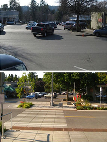
A pedestrian crossing on Winslow Way on Bainbridge Island before (top) and after (bottom) the redesign project emphasizing ADA compliance and stormwater management (image courtesy of FHWA).
- The partnership between Ranson and Charles Town, West Virginia, is a model of planning collaboration. “Two Cities, One Revitalization Plan” was the community mantra as the neighboring towns looked to transform their shared autocentric arterial, Fairfax Boulevard, into a green street and their abandoned industrial brownfields into a renewed commerce corridor. The redesign now makes this thoroughfare both safe and inviting for all modes. New additions to the corridor include bike lanes, widened sidewalks, streetlights, and bus shelters. Stormwater treatment involves a landscaped median with bioswales designed to capture, treat, and infiltrate runoff through soils and plants, including 2,000 new street trees and shrubs.
- The Winslow Way Redesign successfully highlights the importance of Winslow Way as a pedestrian activity center for Bainbridge Island, Washington. With an emphasis on ADA compliance, pedestrian safety, and green infrastructure, the half-mile redesign repaired and widened sidewalks where previously people were forced to travel single file to navigate between poles and benches. To reduce runoff pollution and manage storm events, rain gardens, street trees, underground retention and filtration cells, and pervious concrete sidewalks were added to the corridor.
- Ohiopyle Borough in western Pennsylvania has under 100 residents, but over 1.4 million annual visitors who come to visit Ohiopyle State Park and nearby attractions such as Frank Lloyd Wright’s Fallingwater and Kentuck Knob. The Ohiopyle Green Streets Project greatly improved pedestrian connectivity and stormwater management along three streets near the visitor’s center and primary commercial establishments. The Green Streets Project aimed to better control and clean stormwater flowing into the adjacent Youghiogheny River. To meet these goals, the project used multiple green infrastructure techniques including pervious pavers, bioretention, and bioswales. These stormwater improvements were paired with a more pedestrian-friendly roadway cross-section that included ADA-compliant sidewalks and a multi-use path connecting all major tourist destinations in town.
Contact Information
Gary Jensen
FHWA Office of Human Environment
(202) 366-2048
Gary.Jensen@dot.gov
Susan Jones
FHWA Office of Project Development and Environmental Review
(202) 493-2139
Susan.Jones@dot.gov
Look What’s New!
- FHWA recently released a Guidebook for Measuring Multimodal Network Connectivity. This resource focuses on measuring pedestrian and bicycle network connectivity and incorporating connectivity analysis into the transportation planning process.
- Nominations for the 2019 Environmental Excellence Awards will be accepted from August 1-September 14, 2018. The awards recognize outstanding transportation projects, processes, and organizations that incorporate environmental stewardship into the planning and project development processes using FHWA funding sources. For additional information and to submit your nominations visit this page.
Successes in Stewardship is a Federal Highway Administration newsletter highlighting current environmental streamlining and stewardship practices from around the country. Click here to subscribe, or call (617) 494-2013 for more information.

