Eco-Logical: An Ecosystem Approach to
Developing Infrastructure Projects
II. Setting the Stage

Using the Eco-Logical approach, agencies can collaborate, share resource data and plans, and agree on the location of ecologically important areas and the important resources there. When possible, they may then try to avoid infrastructure development in these areas. If mitigation is necessary, it can be directed to the particularly important locations in order to achieve the greatest ecosystem benefit.
While any agency implementing or mitigating infrastructure projects could use Eco-Logical's proposed approach, transportation-related examples are the focus here. Today, projects address system capacity, maintenance, and safety. Some of these projects improve traffic flow without adding substantial lengths of new lanes or alignments. Projects that are related to facilities on existing alignments provide little opportunity for avoidance and minimization. Similarly, should mitigation be required, these projects are often not located within areas that present the best opportunities for environmental stewardship and ecological gain. Positive opportunities can be permanently lost when the traditional, project-specific approach to avoiding, minimizing, reducing, or compensating impacts is used.
The hypothetical scenario discussed here illustrates this condition. In the map below, the green areas indicate the region's ecologically most vital areas. These areas may include important wildlife, habitat, biologically diverse and productive forests, wetlands and water resources, or other important environmental features. The potential for meaningful conservation and environmental stewardship efforts is significant in these areas.
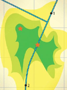
Map of planned infrastructure projects and ecologically important areas. Numbers indicate infrastructure project locations, green indicates the most ecologically vital areas, while the stars show opportunities for the most meaningful mitigation, should it be necessary.
A transportation agency (the action agency in the scenario: an agency whose actions may impact the quality of the human and/or natural environment) has Projects 1 and 2 planned along an existing corridor in the region. Examples of these projects could include roadway reconstruction, overlays and widening, the creation of turning lanes, and/or the installation of guardrails and barriers, among others. The stars indicate places of ecological importance where mitigation opportunities exist. Potential mitigation projects here might be a land purchase for conservation, the reestablishment of a stream meander, or the creation of a wildlife crossing, among many others.
As shown on the map, the planned transportation projects are not located within the areas of highest ecological priority. Traditionally, resource agencies (agencies that have jurisdiction over a resource that may be affected by some activity) would be charged with the task of reacting to Projects 1 and 2 individually. This type of narrow review can lead to mitigation on a restricted, project-by-project basis. In the past, the starred mitigation opportunities—the results of which would likely benefit all agencies—might not be seized because:
- They were not planned; or more importantly,
- The transportation agency was left asking: "What is in it for us if we contribute transportation dollars to this priority area?"
This does not mean that traditional, project-specific mitigation is not significant or beneficial. It means that without broader program, resource, geographic, and temporal perspectives - that is, without an ecosystem approach - any required on-site mitigation may not go as far as possible toward advancing the highest priority ecological and infrastructure goals.
A similar and common scenario concerns the cumulative impacts stemming from a multitude of projects. Often it is challenging for action agencies to identify the indirect and cumulative impacts of their individual projects as required under the National Environmental Policy Act (NEPA) and Section 404 of the Clean Water Act (CWA). If agencies could graphically show how current or proposed projects are related and how they interact, the cumulative effects that can occur could be better determined. This could enable more effective planning and design of projects and any resulting mitigation.
Using the Eco-Logical approach, agencies can collaborate, share resource data and plans, and agree on the locations of ecologically important areas and the important resources there. When possible, they may then try to avoid infrastructure development in these areas. If mitigation is necessary, it can be directed to the particularly important locations—even if the resources there are off-site and/or out-of-kind—in order to achieve the greatest ecosystem benefit. (Off-site - at a location not bordering the impact site. Out-of-kind - other or different resources or ecological functions than those impacted.)
A way to set the stage for agencies and their partners to do similar work is through integrated planning. Chapter III describes a process for adopting this approach.
Avoidance, Minimization, and Compensatory Mitigation: The Sequence
CEQ has defined mitigation in 40 CFR 1508.20 to include: avoiding impacts, minimizing impacts, rectifying impacts, reducing impacts over time, and compensating for impacts. The Clean Water Act (CWA) Section 404 (b)(1) Guidelines establish environmental criteria that must be met for activities to be permitted under the CWA in order to meet the mandate of restoring and maintaining aquatic resources. CEQ's mitigation is wholly compatible with the requirements of the CWA Guidelines; however, they can be combined to form three general types: avoidance, minimization, and compensatory mitigation.
In evaluating Section 404 applications, the USACE first makes a determination that potential impacts have been avoided to the maximum extent practicable; remaining unavoidable impacts will then be minimized to the maximum extent appropriate and practicable and, finally, compensated for. It is this sequence - avoidance, minimization, and compensatory mitigation - that provides for the adherence to the requirements of the CWA. This allows permit issuance for the practicable alternative least environmentally damaging to the aquatic environment and that does not have other significant, adverse environmental consequences.

