Geographic Information Systems Inventory Helps Preserve
Apache Trail’s Historic Character

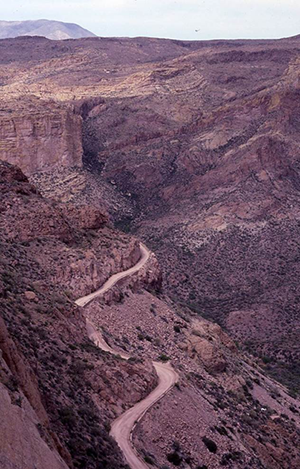
Built as a wagon road in the early 1900s, the winding Apache Trail features numerous character-defining elements in need of maintenance. (Courtesy of USFS)
Many State highway agencies face a difficult balancing act between preserving the character of historically significant roadways and performing necessary maintenance to make these roads suitable for modern travel. To help preserve the unique historical engineering features of the Apache Trail in Arizona, several Federal and State agencies created a Geographic Information Systems (GIS) Inventory of every man-made element on the road. Each of these elements was evaluated to determine which ones were character-defining, such as historical guardrails and bridges. A character-defining element is generally considered a feature that is essential in conveying the identity and significance of a historic resource. The GIS Inventory will allow for streamlined collaboration on future maintenance and operations activities.
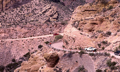
The Apache Trail runs over 40 miles along the Canyon and Apache Lakes just outside of Phoenix, Arizona and stretches south to the Superstition Wilderness Area. Originally constructed in the early 1900s as a wagon haul road for supplies, equipment, and people going between the Roosevelt Dam and the Salt River Valley, the road quickly became a tourist route to view the dam construction. The surrounding scenery soon came to equal the dam as an attraction and today serves as the main draw for travelers to the roadway. The State added the Apache Trail into the highway system in 1922 so that the tourist traffic could be maintained and the road is now part of Arizona’s historically significant State Route 88. The Apache Trail became a National Forest Scenic Byway in 1998. Today, parts of the Apache Trail remain unpaved and only wide enough for one car, with turnouts to manage the moderate-to-heavy traffic on weekends.
In 2009, the Central Federal Lands Highway Division (CFLHD) of the Federal Highway Administration (FHWA), the Arizona Department of Transportation (ADOT), and the U.S. Forest Service (USFS) agreed that they needed an accurate inventory of all the man-made structures that made the Apache Trail eligible for the National Register of Historic Places. Without a comprehensive inventory, ADOT found it challenging to plan and prioritize maintenance operations. CFLHD worked with ADOT and USFS to create a GIS Inventory of the roadway’s man-made elements. In 2013, the Apache Trail Historic GIS Inventory won a FHWA Environmental Excellence Award in the Geospatial Tools, Technology, and Analysis category.
Agencies Create Inventory of Cultural Landmarks
Like many heavily traveled older roadways that are valued for their scenic vistas and economic contribution to the tourist industry, some parts of the Apache Trail are deteriorating and require maintenance. Widening the road would be expensive and could destroy the cultural integrity that made the road eligible for the National Register of Historic Places. Previously, ADOT completed road repair projects as necessary. One such road repair project uncovered a retaining wall that once formed the road’s edge but in later years had been covered by a road-widening project. After this discovery, ADOT, CFLHD, and USFS recognized that there were probably other hidden and undocumented structures along the road and that they needed to have a more thorough understanding of these structures to adequately preserve the roadway and appropriately plan for future projects.
With $450,000 from Federal and State funds, CFLHD selected an engineering firm to detail all of the man-made elements along a roughly 39-mile section of the Apache Trail inside the Tonto National Forest. Surveyors walked the entire stretch of paved and unpaved roadway, noting all of the roadway’s features, which they located geospatially, photographed, video logged, inspected, and entered into a comprehensive GIS database. USFS required that the surveyors catalog every man-made feature, including fords and one-lane bridges. While many of the documented objects may not have historical significance today, 50 years from now they could become character-defining elements of the Apache Trail. This part of the project took one year to complete.
The project team reviewed the entire GIS Inventory and identified several hundred man-made elements that it considered historically significant to the roadway. While most of the character-defining features along Apache Trail do not predate the automobile, a number of elements date to the wagon era, including many of the retaining walls.
Future Benefits of the Inventory
The GIS Inventory will help ADOT, CFLHD, and the Tonto National Forest to do the following:
Prioritize Maintenance Operations
Before the database, ADOT carried out repairs on an as-needed basis, an approach that did not take into account maintaining the historic integrity of the entire roadway. Because the GIS Inventory includes the condition of each man-made element on the roadway, ADOT has a better picture of which elements are most in need of repair and can use that information to create a maintenance plan. Knowing the condition of the roadway prior to starting a project helps ADOT curb construction costs and limit overruns. It also means that elements of the roadway that are not considered character-defining (e.g., modern road signs and pavement) can be repaired in the most cost-effective manner. For elements that are considered historically important, ADOT, USFS, and the Arizona State Historic Preservation Office can work together to decide on a course of action.

A road crew works near a historical stone wall on the Apache Trail in the Tonto National Forest. (Courtesy of USFS)
Streamline Collaboration
A major benefit of the GIS Inventory is that it allows all stakeholders to view the same set of data. Each organization can agree to the specific location of the structure using GIS mapping, while video and photos accurately depict the condition of each item in the database. This provides a solid foundation for various stakeholders to make joint decisions about how best to preserve the road, instead of engaging in reactive maintenance. With all the man-made elements in the GIS database photographed and video logged, stakeholder agencies can view the same data sets to create operations and maintenance plans based on agreement between all of the agencies.
Comply with Section 106
The Apache Trail is eligible for the National Register of Historic Places partially due to its historically significant features like culverts, ditches, and dry-stack retaining walls. Section 106 of the National Historic Preservation Act requires Federal agencies to take into account historic properties that may be affected by their undertakings. The GIS database will help the project’s partners develop a programmatic agreement in compliance with Section 106.
Inventory Facilitates Preservation and Maintenance
On a road that was originally built for mules pulling wagons and stagecoaches, preserving the historic character of the Apache Trail while performing the maintenance necessary to make it passable for today’s travelers requires close coordination among several agencies. Decisionmaking is streamlined when all parties agree on the timing and scope of the maintenance required. By creating a GIS Inventory that comprehensively documents the character-defining elements of the roadway, Federal and State transportation agencies can join with historic preservation groups to create a programmatic approach to preserve this important piece of our national heritage.
Moving forward, the project partners will build on the spirit of cooperation developed while compiling the GIS Inventory to finalize a maintenance plan and programmatic agreement and determine which party is responsible for maintaining the inventory. CFLHD’s GIS Inventory serves as a model for other historically significant roadways within Arizona and other parts of the country facing similar challenges.
Contact Information
Tom Puto
Central Federal Lands Highway Division
Federal Highway Administration
(720) 963-3728
Tom.Puto@dot.gov
Michael Sullivan
U.S. Forest Service
(602) 225-5233
MSullivan@fs.fed.us
Look What’s New!
- FHWA is extending the deadline for the INVEST Implementation Projects letters of interest. The new deadline is March 28 to submit letters of interest to FHWA Division offices. FHWA is offering funding for State departments of transportation, metropolitan planning organizations, and Federal lands to apply FHWA’s sustainability self-assessment tool, INVEST 1.0, and gather lessons learned. Click here for more information.
- The Eco-Logical Webinar Series will present a webinar on March 27th about Step 8 of Integrated Ecological Framework, where agencies deliver projects and implement the previous steps of the Eco-Logical ecosystems approach to environmental mitigation. The Integrated Ecological Framework is a tool designed to help transportation and resource agencies work together to integrate transportation and ecological decisionmaking. The webinar is from 3PM to 4PM ET.
- An Executed Memorandum of Understanding for the Texas Department of Transportation to assume FHWA’s responsibilities for Categorical Exclusions (CEs) became effective on February 12th. Texas joins California, Utah, and Alaska in taking on the responsibilities for NEPA decisionmaking for highway projects that require CE determinations. Click here for more information.
Successes in Stewardship is a Federal Highway Administration newsletter highlighting current environmental
streamlining and stewardship practices from around the country. Click here to subscribe, or call 617-494-3539 for more information.

